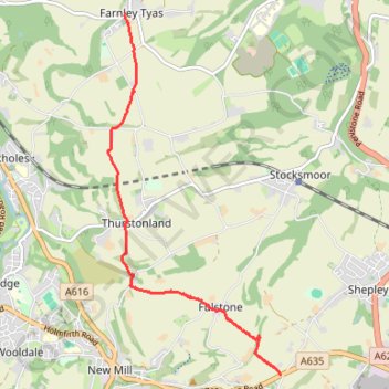
Gate Foot to Farnley Tyas via Thurstonland
Gate Foot - Snowgate Head - Fulstone - Biggin - Top of the Bank - Thurstonland - Top of the Hill - Farnley Tyas
- Distance: 3.6 mi
- Elevation gain: 142 m
- Maximum elevation: 288 m
- Elevation loss: 169 m
- Minimum elevation: 202 m
- Moving time: 1 h 48 m
- Moving speed: 2.0 mph
- Maximum speed: 3.5 mph
- Total time: 2 h 17 m
- Global speed: 1.6 mph
- Date: 25/04/24
Interactive map
GPS track profile
About this GPS track
Name: Gate Foot to Farnley Tyas via Thurstonland GPS track, route, trail
Coordinates: 53.57459 -1.75583 53.61108 -1.72628
Topography: Kirklees topographic map