Volcán Teneguía. La Palma
Randonnée pédestre. Depuis Los Canarios. #Randonnée
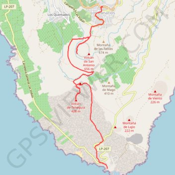
- Distance: 6.0 mi
- Elevation gain: 102 m
- Maximum elevation: 718 m
- Elevation loss: 805 m
- Minimum elevation: 14 m
- Moving time: 2 h 28 m
- Moving speed: 2.4 mph
- Maximum speed: 4.3 mph
- Total time: 3 h 27 m
- Global speed: 1.7 mph
- Date: 29/07/09
Interactive map
GPS track profile
About this GPS track
Name: Volcán Teneguía. La Palma GPS track, route, trail
Coordinates: 28.45551 -17.85395 28.49414 -17.84333
Other GPS tracks
Click on a GPS track to view route, its statistics and profile.
LaPal_51_Los Canarios - San Antonio - Teneguia - Faro
Espagne > Fuencaliente de la Palma > Los Canarios
Distance: 8.1 mi • Elevation gain: 731 m • Maximum elevation: 646 m