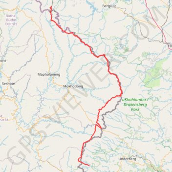
Grande traversée du Drakensberg
#Randonnée #Drakensberg #Lesotho
- Distance: 127.8 mi
- Elevation gain: 7,514 m
- Maximum elevation: 3,447 m
- Elevation loss: 8,250 m
- Minimum elevation: 2,018 m
- Moving time: 12 h 42 m
- Moving speed: 10.1 mph
- Maximum speed: 12.2 mph
- Total time: 12 h 42 m
- Global speed: 10.1 mph
- Date: 01/01/10
Interactive map
GPS track profile
About this GPS track
Name: Grande traversée du Drakensberg GPS track, route, trail
Coordinates: -29.84035 28.87992 -28.73686 29.45071
Other GPS tracks
Click on a GPS track to view route, its statistics and profile.
Chain Ladder Path
Afrique du Sud > État-Libre > Thabo Mofutsanyana District Municipality > Maluti-a-Phofung Local Municipality
Distance: 2.9 mi • Elevation gain: 623 m • Maximum elevation: 3,006 m
Thukela Falls - Sentinel
South Africa > Free State > Thabo Mofutsanyana District Municipality > Maluti-a-Phofung Local Municipality
#Hike
Distance: 7.9 mi • Elevation gain: 1,003 m • Maximum elevation: 3,006 m