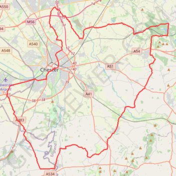
Bike Loop from Chester
#Bike #Loop #Road #Countryside #Nature
- Distance: 51.4 mi
- Elevation gain: 532 m
- Maximum elevation: 163 m
- Elevation loss: 533 m
- Minimum elevation: 6 m
Interactive map
GPS track profile
About this GPS track
Name: Bike Loop from Chester GPS track, route, trail
Coordinates: 53.07887 -2.97092 53.26081 -2.66587
Topography: Chester topographic map
Other GPS tracks
Click on a GPS track to view route, its statistics and profile.
TT22 J9 M7/06 : Heysham Port à Aberystwyth
Royaume-Uni > Angleterre > Lancashire > Lancaster > Morecambe
Distance: 215.9 mi • Elevation gain: 4,043 m • Maximum elevation: 419 m