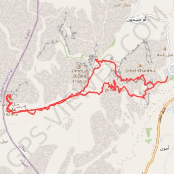
Mont Aaron (Jordanie)
Randonnée pédestre. #Randonnée
- Distance: 13.7 mi
- Elevation gain: 1,148 m
- Maximum elevation: 1,307 m
- Elevation loss: 1,183 m
- Minimum elevation: 867 m
- Moving time: 5 h 59 m
- Moving speed: 2.3 mph
- Maximum speed: 22.3 mph
- Total time: 9 h 15 m
- Global speed: 1.5 mph
- Date: 16/09/09
Interactive map
GPS track profile
About this GPS track
Name: Mont Aaron (Jordanie) GPS track, route, trail
Coordinates: 30.31112 35.40520 30.32969 35.46760