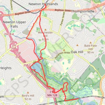
Cutler Park Reservation Loop
Loop hike from Newton Highlands via Winchester Street, Nahanton Park, Charles River, Kendrick Street, Healthy Heart Trail, Kendrick Pond, Blue Heron Trail, Powells Island, Fourth Avenue, Upper Charles River Reservation and Needham Street. #Hike #Loop #Nature #Forest #River #City
- Distance: 10.3 mi
- Elevation gain: 108 m
- Maximum elevation: 49 m
- Elevation loss: 107 m
- Minimum elevation: 25 m
- Moving time: 3 h 27 m
- Moving speed: 3.0 mph
- Maximum speed: 4.4 mph
- Total time: 5 h 14 m
- Global speed: 2.0 mph
- Date: 27/01/19
Interactive map
GPS track profile
About this GPS track
Name: Cutler Park Reservation Loop GPS track, route, trail
Coordinates: 42.27817 -71.21724 42.32185 -71.18568
Other GPS tracks
Click on a GPS track to view route, its statistics and profile.
Wellesley wandering
United States > Massachusetts > Middlesex County > Newton
Some Wellesley trails
Distance: 41.4 mi • Elevation gain: 611 m • Maximum elevation: 106 m
Medford trails
United States > Massachusetts > Middlesex County > Newton
Distance: 46.0 mi • Elevation gain: 684 m • Maximum elevation: 94 m
Cambridge - Providence Express
United States > Massachusetts > Middlesex County > Cambridge
Alewife -> Providence
Distance: 63.2 mi • Elevation gain: 961 m • Maximum elevation: 107 m