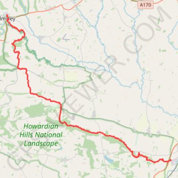
Ryedale Trail Running
Malton to Helmsley trot. #Run #Nature #Forest #Countryside
- Distance: 18.6 mi
- Elevation gain: 430 m
- Maximum elevation: 117 m
- Elevation loss: 393 m
- Minimum elevation: 23 m
- Moving time: 3 h 45 m
- Moving speed: 4.9 mph
- Maximum speed: 8.5 mph
- Total time: 3 h 49 m
- Global speed: 4.9 mph
- Date: 02/02/24
Interactive map
GPS track profile
About this GPS track
Name: Ryedale Trail Running GPS track, route, trail
End: 1,3, Carlton Lane, Helmsley, North Yorkshire, England, YO62 5HB, United Kingdom (54.24841 -1.05699)
Coordinates: 54.12498 -1.05711 54.24854 -0.82105
Topography: North Yorkshire topographic map