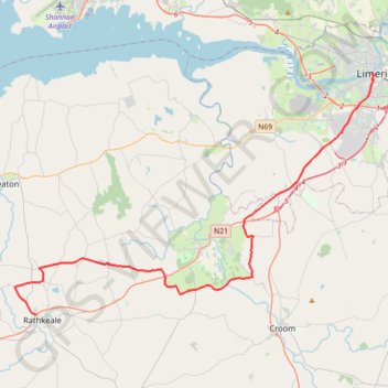
28: Limerick – Rathkeale (Developed with signs)
- Distance: 23.2 mi
- Elevation gain: 201 m
- Maximum elevation: 62 m
- Elevation loss: 172 m
- Minimum elevation: 5 m
Interactive map
GPS track profile
About this GPS track
Name: 28: Limerick – Rathkeale (Developed with signs) GPS track, route, trail
Coordinates: 52.52636 -8.96268 52.66129 -8.63282
Other GPS tracks
Click on a GPS track to view route, its statistics and profile.
RT5-1 Rosslare - Kinsale
Distance: 1,777.3 mi • Elevation gain: 27,381 m • Maximum elevation: 420 m
Trace IRELAND
Distance: 936.2 mi • Elevation gain: 13,359 m • Maximum elevation: 524 m
RT5-1 Rosslare - Kinsale
Distance: 2,402.9 mi • Elevation gain: 36,115 m • Maximum elevation: 524 m
RT5-1 Rosslare - Kinsale
Distance: 841.0 mi • Elevation gain: 15,245 m • Maximum elevation: 420 m