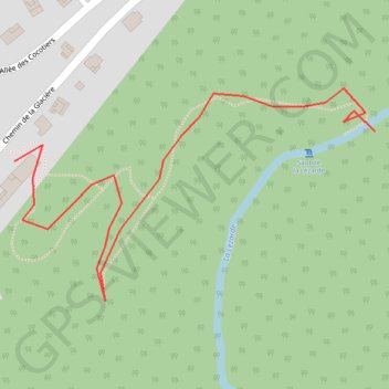
Saut Lezarde
- Distance: 0.5 mi
- Elevation gain: 0 m
- Maximum elevation: 191 m
- Elevation loss: 65 m
- Minimum elevation: 125 m
Interactive map
GPS track profile
About this GPS track
Name: Saut Lezarde GPS track, route, trail
End: Chemin de Vernou, Vernou, Petit-Bourg, Basse-Terre, Guadeloupe, 97170, France (16.17790 -61.65495)
Coordinates: 16.17658 -61.65788 16.17824 -61.65495
Other GPS tracks
Click on a GPS track to view route, its statistics and profile.
45 Km
France > Guadeloupe > Lamentin > Crâne
Distance: 28.5 mi • Elevation gain: 834 m • Maximum elevation: 266 m