Lake Isabelle and Long Lake Loop
Interactive map
GPS track profile
About this GPS track
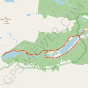
Name: Lake Isabelle and Long Lake Loop GPS track, route, trail
Coordinates: 40.06790 -105.62242 40.07787 -105.58446
Other GPS tracks
Click on a GPS track to view route, its statistics and profile.
Lone Eagle Peak - Pawnee Pass
United States > Colorado > Grand County
Lake Ganby, Monarch Lake, Crater Lake, Triangle Lake, Pawnee Lake, Lake Isabelle, Long Lake. Rocky Mountains. #Hike #RockyMountains
Distance: 20.4 mi • Elevation gain: 2,006 m • Maximum elevation: 3,824 m