Bray - Greystones
#Hike
- Distance: 11.2 mi
- Elevation gain: 511 m
- Maximum elevation: 74 m
- Elevation loss: 511 m
- Minimum elevation: 0 m
Interactive map
GPS track profile
About this GPS track
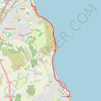
Name: Bray - Greystones GPS track, route, trail
Coordinates: 53.14418 -6.10109 53.20458 -6.05998
Other GPS tracks
Click on a GPS track to view route, its statistics and profile.
RT5-1 Rosslare - Kinsale
Distance: 2,402.9 mi • Elevation gain: 36,115 m • Maximum elevation: 524 m