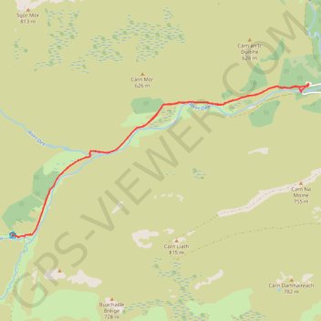
Planned eMTB Gravel: Linn of Dee -> The Red House Bothy - TnB
Following the River Dee west from the Linn of Dee
- Distance: 9.5 mi
- Elevation gain: 100 m
- Maximum elevation: 441 m
- Elevation loss: 100 m
- Minimum elevation: 373 m
- Moving time: 1 h 9 m
- Moving speed: 8.2 mph
- Maximum speed: 18.5 mph
- Total time: 1 h 53 m
- Global speed: 5.0 mph
- Date: 31/03/24
Interactive map
GPS track profile
About this GPS track
Name: Planned eMTB Gravel: Linn of Dee -> The Red House Bothy - TnB GPS track, route, trail
Start: Linn of Dee, C1M, Aberdeenshire, Scotland, AB35 5YB, United Kingdom (56.98943 -3.54308)
End: Linn of Dee, C1M, Aberdeenshire, Scotland, AB35 5YB, United Kingdom (56.98965 -3.54316)
Coordinates: 56.96186 -3.64151 56.98965 -3.54308
Topography: Aberdeenshire topographic map