Netherton woods circular
- Distance: 3.9 mi
- Elevation gain: 147 m
- Maximum elevation: 204 m
- Elevation loss: 144 m
- Minimum elevation: 112 m
- Moving time: 2 h 16 m
- Moving speed: 1.7 mph
- Maximum speed: 3.9 mph
- Total time: 3 h 4 m
- Global speed: 1.3 mph
- Date: 30/03/24
Interactive map
GPS track profile
About this GPS track
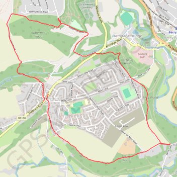
Name: Netherton woods circular GPS track, route, trail
Coordinates: 53.60795 -1.82129 53.62249 -1.79456
Topography: Kirklees topographic map