Brent Eleigh and Lavenham Walk
- Distance: 10.6 mi
- Elevation gain: 130 m
- Maximum elevation: 84 m
- Elevation loss: 129 m
- Minimum elevation: 46 m
- Moving time: 4 h 10 m
- Moving speed: 2.5 mph
- Maximum speed: 4.0 mph
- Total time: 5 h 31 m
- Global speed: 1.9 mph
- Date: 05/05/24
Interactive map
GPS track profile
About this GPS track
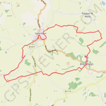
Name: Brent Eleigh and Lavenham Walk GPS track, route, trail
Start: Hall Road, Brent Eleigh, Babergh, Suffolk, England, CO10 9SU, United Kingdom (52.09616 0.83519)
End: Hall Road, Brent Eleigh, Babergh, Suffolk, England, CO10 9SU, United Kingdom (52.09627 0.83516)
Coordinates: 52.08623 0.76853 52.11430 0.84749
Topography: Babergh topographic map
Other GPS tracks
Click on a GPS track to view route, its statistics and profile.
Braintree-Norwich-115km
Royaume-Uni > Angleterre > Essex > Braintree > Bocking Churchstreet
Distance: 70.8 mi • Elevation gain: 752 m • Maximum elevation: 94 m