Deacon Hill
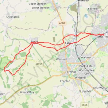
Letchworth, Ickleford, Pirton, Deacon Hill and return
- Distance: 16.4 mi
- Elevation gain: 293 m
- Maximum elevation: 182 m
- Elevation loss: 293 m
- Minimum elevation: 48 m
- Moving time: 6 h 7 s
- Moving speed: 2.7 mph
- Maximum speed: 3.9 mph
- Total time: 7 h 2 m
- Global speed: 2.3 mph
- Date: 07/04/23
Interactive map
GPS track profile
About this GPS track
Name: Deacon Hill GPS track, route, trail
Coordinates: 51.94368 -0.37120 51.97982 -0.23311
Topography: North Hertfordshire topographic map
Other GPS tracks
Click on a GPS track to view route, its statistics and profile.
From Royston to Letchworth
United Kingdom > England > Hertfordshire > North Hertfordshire > Royston
Distance: 14.7 mi • Elevation gain: 260 m • Maximum elevation: 168 m
Route
United Kingdom > England > Central Bedfordshire > Upper Sundon
Distance: 70.2 mi • Elevation gain: 903 m • Maximum elevation: 170 m