Bridges to Bishops Castle
- Distance: 11.7 mi
- Elevation gain: 548 m
- Maximum elevation: 527 m
- Elevation loss: 588 m
- Minimum elevation: 169 m
- Moving time: 5 h 22 m
- Moving speed: 2.2 mph
- Maximum speed: 3.4 mph
- Total time: 7 h 8 m
- Global speed: 1.6 mph
- Date: 19/04/24
Interactive map
GPS track profile
About this GPS track
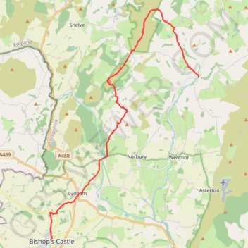
Name: Bridges to Bishops Castle GPS track, route, trail
Start: Bridges, Ratlinghope, Shropshire, England, SY5 0ST, United Kingdom (52.56254 -2.89652)
End: High Street, Bishop's Castle, Shropshire, England, SY9 5BN, United Kingdom (52.49462 -2.99763)
Coordinates: 52.49462 -2.99917 52.59105 -2.89615
Topography: Shropshire topographic map
Other GPS tracks
Click on a GPS track to view route, its statistics and profile.
Church Stretton to Bridges
United Kingdom > England > Shropshire > Church Stretton
Distance: 9.5 mi • Elevation gain: 410 m • Maximum elevation: 512 m
TT22 J9 M7/06 : Heysham Port à Aberystwyth
Royaume-Uni > Angleterre > Lancashire > Lancaster > Morecambe
Distance: 215.9 mi • Elevation gain: 4,043 m • Maximum elevation: 419 m
RE SO320930
United Kingdom > England > Shropshire > Lydham > Owlbury
Distance: 1.8 mi • Elevation gain: 113 m • Maximum elevation: 231 m