2018-05-13 12:23:22
En boucle. #Boucle
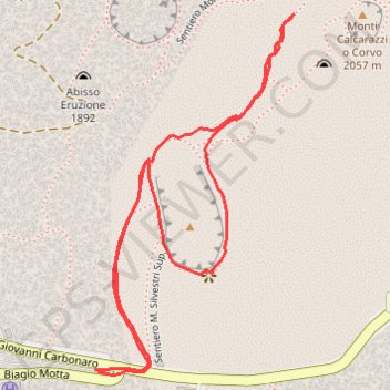
- Distance: 1.3 mi
- Elevation gain: 120 m
- Maximum elevation: 2,003 m
- Elevation loss: 121 m
- Minimum elevation: 1,891 m
- Moving time: 38 m 54 s
- Moving speed: 2.1 mph
- Maximum speed: 3.5 mph
- Total time: 41 m 59 s
- Global speed: 1.9 mph
- Date: 13/05/18
Interactive map
GPS track profile
About this GPS track
Name: 2018-05-13 12:23:22 GPS track, route, trail
Start: Via Giovanni Carbonaro, Nicolosi Nord, Nicolosi, Catane, Sicile, 95030, Italie (37.69907 15.00291)
End: Via Biagio Motta, Nicolosi Nord, Nicolosi, Catane, Sicile, 95030, Italie (37.69904 15.00297)
Coordinates: 37.69899 15.00291 37.70456 15.00680
Other GPS tracks
Click on a GPS track to view route, its statistics and profile.
Vers les sommets de l'Etna
Italie > Sicile > Catane > Zafferana Etnea
Randonnée pédestre. En aller simple. #Randonnée
Distance: 4.4 mi • Elevation gain: 161 m • Maximum elevation: 2,923 m
Randonnée sur l'Etna
Italie > Sicile > Catane > Zafferana Etnea
Distance: 6.9 mi • Elevation gain: 408 m • Maximum elevation: 3,283 m