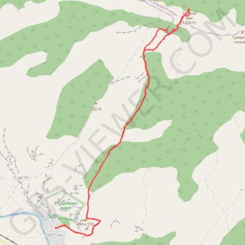
Trenutna trasa: 13 SRP 2019 13:42
- Distance: 7.8 mi
- Elevation gain: 1,123 m
- Maximum elevation: 1,324 m
- Elevation loss: 1,123 m
- Minimum elevation: 273 m
- Moving time: 4 h 24 m
- Moving speed: 1.8 mph
- Maximum speed: 4.6 mph
- Total time: 5 h 4 m
- Global speed: 1.5 mph
- Date: 13/07/19
Interactive map
GPS track profile
About this GPS track
Name: Trenutna trasa: 13 SRP 2019 13:42 GPS track, route, trail
Coordinates: 43.29398 22.22344 43.33044 22.25308
Other GPS tracks
Click on a GPS track to view route, its statistics and profile.
Tour d'Europe
France > Bretagne > Finistère > Concarneau > Landan Creis
Distance: 4,432.2 mi • Elevation gain: 44,603 m • Maximum elevation: 2,433 m
De Giromagny à Sofia
France > Bourgogne-Franche-Comté > Territoire-de-Belfort > Giromagny
Distance: 1,165.7 mi • Elevation gain: 12,108 m • Maximum elevation: 1,054 m