Gravel Bike Vermont
- Distance: 26.9 mi
- Elevation gain: 814 m
- Maximum elevation: 199 m
- Elevation loss: 814 m
- Minimum elevation: 28 m
- Moving time: 2 h 48 m
- Moving speed: 9.6 mph
- Maximum speed: 35.9 mph
- Total time: 3 h 10 m
- Global speed: 8.5 mph
- Date: 27/04/24
Interactive map
GPS track profile
About this GPS track
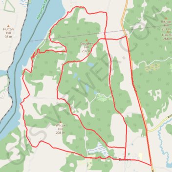
Name: Gravel Bike Vermont GPS track, route, trail
Start: 1782, Lake Road, Benson, Rutland County, Vermont, 05743, United States (43.70730 -73.32966)
End: 1798, Lake Road, Benson, Rutland County, Vermont, 05743, United States (43.70733 -73.32996)
Coordinates: 43.70429 -73.36733 43.76681 -73.29611
Other GPS tracks
Click on a GPS track to view route, its statistics and profile.
Montréal - New York
Canada > Québec > Agglomération de Montréal > Montréal
Distance: 396.0 mi • Elevation gain: 4,134 m • Maximum elevation: 301 m