Lowther hills hillwalk
- Distance: 8.3 mi
- Elevation gain: 594 m
- Maximum elevation: 731 m
- Elevation loss: 594 m
- Minimum elevation: 385 m
- Moving time: 3 h 48 m
- Moving speed: 2.2 mph
- Maximum speed: 6.0 mph
- Total time: 4 h 1 m
- Global speed: 2.1 mph
- Date: 21/04/24
Interactive map
GPS track profile
About this GPS track
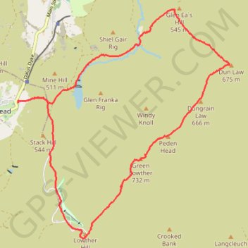
Name: Lowther hills hillwalk GPS track, route, trail
Start: Dumfries and Galloway, Scotland, ML12 6UP, United Kingdom (55.39874 -3.77175)
End: Dumfries and Galloway, Scotland, ML12 6UP, United Kingdom (55.39873 -3.77170)
Coordinates: 55.37715 -3.77180 55.41357 -3.71255
Topography: Dumfries and Galloway topographic map
Other GPS tracks
Click on a GPS track to view route, its statistics and profile.
United Kingdom to Beinglas Campsite
Royaume-Uni > Écosse > Dumfries and Galloway
Distance: 133.9 mi • Elevation gain: 1,837 m • Maximum elevation: 318 m