Rueter Hess Reservoir
mtb mountainbiking biking trails
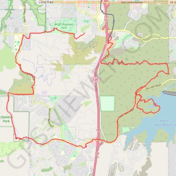
- Distance: 24.9 mi
- Elevation gain: 718 m
- Maximum elevation: 2,011 m
- Elevation loss: 655 m
- Minimum elevation: 1,823 m
- Moving time: 3 h 52 m
- Moving speed: 6.4 mph
- Maximum speed: 27.7 mph
- Total time: 5 h 3 m
- Global speed: 4.9 mph
- Date: 15/04/24
Interactive map
GPS track profile
About this GPS track
Name: Rueter Hess Reservoir GPS track, route, trail
End: Ridgegate Trail, Lone Tree, Douglas County, Colorado, 80124, United States (39.52212 -104.88058)
Coordinates: 39.46829 -104.92786 39.52430 -104.82933