Nicolas_Vanvyve_2021-08-28_16-10-47
- Distance: 7.0 mi
- Elevation gain: 55 m
- Maximum elevation: 114 m
- Elevation loss: 52 m
- Minimum elevation: 100 m
- Moving time: 3 h 22 m
- Moving speed: 2.1 mph
- Maximum speed: 4.5 mph
- Total time: 3 h 38 m
- Global speed: 1.9 mph
- Date: 28/08/21
Interactive map
GPS track profile
About this GPS track
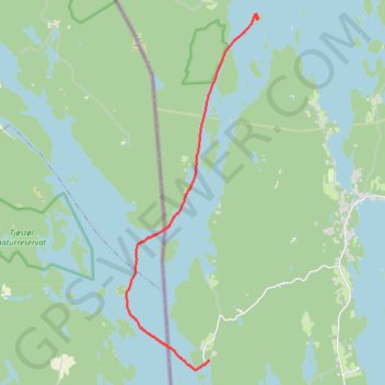
Name: Nicolas_Vanvyve_2021-08-28_16-10-47 GPS track, route, trail
Start: S 508, Grunnerud, Årjängs kommun, Comté de Värmland, Suède (59.28369 11.84025)
End: S 500, Båstnäs, Årjängs kommun, Comté de Värmland, Suède (59.35709 11.86086)
Coordinates: 59.28146 11.80551 59.35772 11.86111
Other GPS tracks
Click on a GPS track to view route, its statistics and profile.
Nicolas_Vanvyve_2021-08-29_11-38-26
Distance: 9.3 mi • Elevation gain: 41 m • Maximum elevation: 107 m
Nicolas_Vanvyve_2021-09-03
Distance: 6.4 mi • Elevation gain: 19 m • Maximum elevation: 109 m
Nicolas_Vanvyve_2021-09-02
Distance: 9.6 mi • Elevation gain: 36 m • Maximum elevation: 115 m