Continental Divide Trail (CDT)
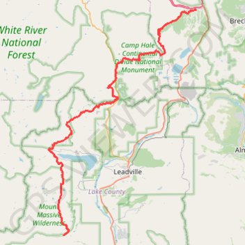
Hike on the Continental Divide National Scenic Trail between Halfmoon Creek and Copper Mountain through Mount Massive Wilderness, Holy Cross Wilderness, White River National Forest and Continental Divide National Monument in the Rocky Mountains. #Hike #CDT #Mountain #Nature #River
- Distance: 49.0 mi
- Elevation gain: 2,807 m
- Maximum elevation: 3,742 m
- Elevation loss: 2,898 m
- Minimum elevation: 2,846 m
Interactive map
GPS track profile
About this GPS track
Name: Continental Divide Trail (CDT) GPS track, route, trail
Start: Forest Road 110 Halfmoon, Lake County, Colorado, United States (39.15132 -106.41894)
End: New Old Road, Copper Mountain, Summit County, Colorado, United States (39.50001 -106.15807)
Coordinates: 39.15132 -106.45021 39.50001 -106.15608
Other GPS tracks
Click on a GPS track to view route, its statistics and profile.