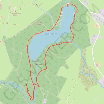
Castle Lake Walks
- Distance: 3.1 mi
- Elevation gain: 74 m
- Maximum elevation: 159 m
- Elevation loss: 77 m
- Minimum elevation: 133 m
- Moving time: 56 m 18 s
- Moving speed: 3.3 mph
- Maximum speed: 6.9 mph
- Total time: 1 h 8 m
- Global speed: 2.7 mph
- Date: 20/04/24
Interactive map
GPS track profile
About this GPS track
Name: Castle Lake Walks GPS track, route, trail
Coordinates: 53.92573 -6.99108 53.93964 -6.97836
Other GPS tracks
Click on a GPS track to view route, its statistics and profile.
Castle Lake Walks
Afternoon Run
Distance: 10.1 mi • Elevation gain: 296 m • Maximum elevation: 179 m
RT5-1 Rosslare - Kinsale
Distance: 1,777.3 mi • Elevation gain: 27,381 m • Maximum elevation: 420 m
RT5-1 Rosslare - Kinsale
Distance: 2,402.9 mi • Elevation gain: 36,115 m • Maximum elevation: 524 m