TP00 STorp-PCovo
- Distance: 6.0 mi
- Elevation gain: 100 m
- Maximum elevation: 27 m
- Elevation loss: 79 m
- Minimum elevation: 2 m
Interactive map
GPS track profile
About this GPS track
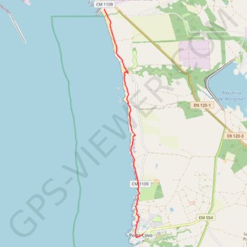
Name: TP00 STorp-PCovo GPS track, route, trail
Start: Parking/parque, CM 1109, Sines, Setúbal, 7520-089, Portugal (37.92690 -8.80702)
End: Rua do Norte, Porto Covo, Sines, Setúbal, 7520-437, Portugal (37.85187 -8.79103)
Coordinates: 37.85083 -8.80702 37.92690 -8.79103
Other GPS tracks
Click on a GPS track to view route, its statistics and profile.
Eurovelo 01 Spain + Portugal
France > Nouvelle-Aquitaine > Pyrénées-Atlantiques > Hendaye
Distance: 1,930.7 mi • Elevation gain: 30,592 m • Maximum elevation: 1,503 m
Southern section — European Divide Trail
France > Auvergne-Rhône-Alpes > Drôme > Valence
Distance: 1,506.1 mi • Elevation gain: 42,375 m • Maximum elevation: 2,005 m
Rota Vicentina - Sentier des pêcheurs - Étape 1
Portugal > Setúbal > Sines > Porto Covo
Porto Covo » Vila Nova de Milfontes
Distance: 12.1 mi • Elevation gain: 403 m • Maximum elevation: 48 m
Stage 26: Valence to Saint-Jean-de-Fos — European Divide Trail
France > Auvergne-Rhône-Alpes > Drôme > Valence
Distance: 1,506.1 mi • Elevation gain: 42,375 m • Maximum elevation: 2,005 m
Stage 26: Valence to Saint-Jean-de-Fos — European Divide Trail
Distance: 533.8 mi • Elevation gain: 16,438 m • Maximum elevation: 1,490 m
Vila do Bispo -> Distrito 4 (495,2 km)
Distance: 811.8 mi • Elevation gain: 23,128 m • Maximum elevation: 2,134 m