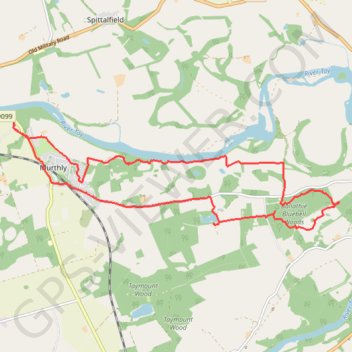
Murthly to Kinclaven Wood, Perthshire
Loop run / hike via Gellyburn, Murthly, River Tay, Ballathie Bluebell Woods and Old England Loch. #Run #Hike #Loop #Nature #Forest #River #Countryside #Lake
- Distance: 9.0 mi
- Elevation gain: 136 m
- Maximum elevation: 82 m
- Elevation loss: 136 m
- Minimum elevation: 33 m
- Moving time: 1 h 27 m
- Moving speed: 6.2 mph
- Maximum speed: 21.1 mph
- Total time: 1 h 33 m
- Global speed: 5.8 mph
- Date: 18/03/24
Interactive map
GPS track profile
About this GPS track
Name: Murthly to Kinclaven Wood, Perthshire GPS track, route, trail
Start: B9099, Gellyburn, Murthly, Perth and Kinross, Scotland, PH1 4HN, United Kingdom (56.53701 -3.47606)
End: B9099, Gellyburn, Murthly, Perth and Kinross, Scotland, PH1 4HN, United Kingdom (56.53696 -3.47600)
Coordinates: 56.52183 -3.47616 56.53701 -3.39273
Topography: Perth and Kinross topographic map