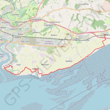
Coast Path Walk
Hike from Rogiet - Seven Tunnel Junction along the Bristol Channel coast via Goldcliff Lagoons, East Usk Lighthouse and Newport Wetlands. #Walk #Hike #Coast #Nature #Sea
- Distance: 14.2 mi
- Elevation gain: 47 m
- Maximum elevation: 12 m
- Elevation loss: 46 m
- Minimum elevation: 0 m
- Moving time: 5 h 21 m
- Moving speed: 2.6 mph
- Maximum speed: 17.9 mph
- Total time: 7 h 10 m
- Global speed: 2.0 mph
- Date: 02/03/24
Interactive map
GPS track profile
About this GPS track
Name: Coast Path Walk GPS track, route, trail
Start: 4, Station Road, Rogiet, Monmouthshire, Wales, NP26 3WF, United Kingdom (51.58439 -2.77752)
Coordinates: 51.53472 -2.97670 51.58522 -2.77680
Topography: Monmouthshire topographic map
Other GPS tracks
Click on a GPS track to view route, its statistics and profile.
TT22 Jo10 M8/06 : Aberystwyth à Cheddar
Royaume-Uni > Pays de Galles > Ceredigion > Aberystwyth
Distance: 153.7 mi • Elevation gain: 3,874 m • Maximum elevation: 515 m