EuroVelo 10 - part Germany
- Distance: 14.5 mi
- Elevation gain: 87 m
- Maximum elevation: 32 m
- Elevation loss: 96 m
- Minimum elevation: -1 m
Interactive map
GPS track profile
About this GPS track
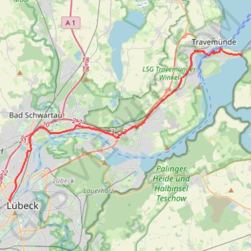
Name: EuroVelo 10 - part Germany GPS track, route, trail
Coordinates: 53.86834 10.67167 53.95846 10.90370
Other GPS tracks
Click on a GPS track to view route, its statistics and profile.
TET-Germany-Section1-20210518
Germany > Schleswig-Holstein > Ostholstein > Fehmarn > Puttgarden
Distance: 297.9 mi • Elevation gain: 1,685 m • Maximum elevation: 127 m
TET-Germany-Section1-20200619
Allemagne > Schleswig-Holstein > Ostholstein > Fehmarn > Puttgarden
Distance: 297.9 mi • Elevation gain: 1,685 m • Maximum elevation: 127 m
E1_Germany 3
Allemagne > Schleswig-Holstein > Schleswig-Flensburg > Oeversee
Distance: 1,179.3 mi • Elevation gain: 33,186 m • Maximum elevation: 1,446 m