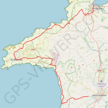
01: Fishguard – Haverfordwest (DEVELOPED_WITH_SIGNS)
DEVELOPED_WITH_SIGNS
- Distance: 39.5 mi
- Elevation gain: 995 m
- Maximum elevation: 127 m
- Elevation loss: 911 m
- Minimum elevation: -1 m
Interactive map
GPS track profile
About this GPS track
Name: 01: Fishguard – Haverfordwest (DEVELOPED_WITH_SIGNS) GPS track, route, trail
Coordinates: 51.78264 -5.27367 52.00328 -4.98736
Other GPS tracks
Click on a GPS track to view route, its statistics and profile.
01: Fishguard – Haverfordwest (Developed with signs)
Royaume-Uni > Pays de Galles > Pembrokeshire > Fishguard
Developed with signs
Distance: 52.5 mi • Elevation gain: 1,166 m • Maximum elevation: 126 m