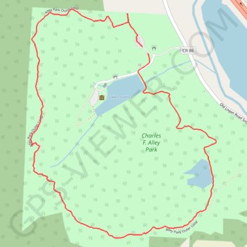
Alley Park Loop
Loop hike through Charles F. Alley Park around Lake Loretta via Alley Park Outer Loop. #Hike #Loop #Park #Nature #Forest #Lake
- Distance: 2.3 mi
- Elevation gain: 120 m
- Maximum elevation: 326 m
- Elevation loss: 120 m
- Minimum elevation: 256 m
- Moving time: 1 h 4 m
- Moving speed: 2.2 mph
- Maximum speed: 4.5 mph
- Total time: 1 h 11 m
- Global speed: 2.0 mph
- Date: 09/07/23
Interactive map
GPS track profile
About this GPS track
Name: Alley Park Loop GPS track, route, trail
End: Berne Township, Fairfield County, Ohio, 43130, United States (39.68190 -82.57665)
Coordinates: 39.67408 -82.58310 39.68377 -82.57288
Other GPS tracks
Click on a GPS track to view route, its statistics and profile.
Alley Park trails
United States > Ohio > Fairfield County
Distance: 2.0 mi • Elevation gain: 109 m • Maximum elevation: 303 m