Import a GPX file

Regent's Park and Hyde Park Loop

Loop hike from Queen's Park to Regent's Park and Hyde Park. #Hike #Loop #City #London #Park #Nature #Lake #Forest

  • Distance: 9.1 mi
  • Elevation gain: 117 m
  • Maximum elevation: 53 m
  • Elevation loss: 118 m
  • Minimum elevation: 14 m

Interactive map

GPS track profile

About this GPS track
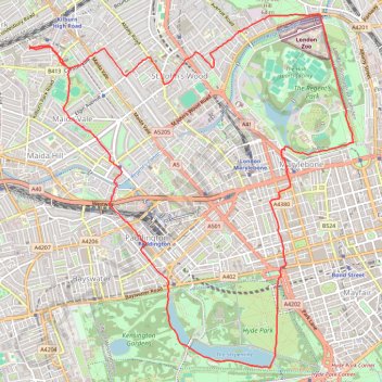
Other GPS tracks

Click on a GPS track to view route, its statistics and profile.

Paris - Londres à vélo

France > Île-de-France > Paris

Vélo entre Paris et Londres. #Vélo #Paris #Londre

Distance: 263.1 mi • Elevation gain: 2,176 m • Maximum elevation: 231 m

Tour de Londres

Royaume-Uni > Angleterre > Londres

Vélo. En boucle depuis Londres. #Vélo #Boucle

Distance: 46.4 mi • Elevation gain: 296 m • Maximum elevation: 43 m

Newhaven Londres

Royaume-Uni > Angleterre > Cité de Londres

Vélo. En aller simple entre Londres et Newhaven. #Vélo

Distance: 96.7 mi • Elevation gain: 1,139 m • Maximum elevation: 202 m

St John's Wood Loop

United Kingdom > England > London

Loop walk through St John's Wood via Primrose Hill, Regent's Park, Abbey Road and Paddington Recreation Ground. #Walk #Hike #Loop #City #Park #Nature

Distance: 6.7 mi • Elevation gain: 99 m • Maximum elevation: 62 m

Queen's Park Loop

United Kingdom > England > London

Loop hike around Queen's Park. #Walk #Hike #Loop #City #River #Park #Nature

Distance: 5.1 mi • Elevation gain: 56 m • Maximum elevation: 61 m