Autour du Mont Doville - Lahaye-du-Puits
Interactive map
GPS track profile
About this GPS track
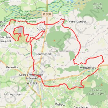
Name: Autour du Mont Doville - Lahaye-du-Puits GPS track, route, trail
Coordinates: 49.28427 -1.58449 49.33954 -1.46401
Other GPS tracks
Click on a GPS track to view route, its statistics and profile.
GR 223 Tour du Cotentin (2021)
France > Normandie > Eure > Berville-sur-Mer
Randonnée en Normandie sur le GR 223 autour du Cotentin à travers l'Eure, le Calvados et la Manche de Berville-sur-Mer au Mont-Saint-Michel.
Distance: 404.3 mi • Elevation gain: 6,685 m • Maximum elevation: 149 m
GR 223 : De Carentan à Cherbourg (Manche)
France > Normandie > Manche > Carentan-les-Marais
Randonnée en Normandie sur le GR 223, Le sentier du littoral, à travers la Manche de Carentan à Cherbourg via Brucheville, Sainte-Mère-Église, Tatihou (Saint-Vaast-la-Hougue), Saint-Vaast-la-Hougue et Saint-Pierre-Église. #Randonnée #GR223 #Mer #Campagne #Manche #Normandie #Cotentin #Nature
Distance: 79.9 mi • Elevation gain: 694 m • Maximum elevation: 149 m
Tour d'Europe
France > Bretagne > Finistère > Concarneau > Landan Creis
Distance: 4,432.2 mi • Elevation gain: 44,603 m • Maximum elevation: 2,433 m
Sentier Cotentin - Cherbourg vers Mont-Saint-Michel
France > Normandie > Manche > La Hague > Urville-Nacqueville > La Rivière
Distance: 144.0 mi • Elevation gain: 2,584 m • Maximum elevation: 128 m
GR223 - Cherbourg à Coutances
France > Normandie > Manche > Cherbourg-en-Cotentin
Randonnée entre Cherbourg-Octeville et Coutances. #Randonnée
Distance: 125.1 mi • Elevation gain: 2,106 m • Maximum elevation: 138 m
RAF 2022 / 2600 n1 News
France > Hauts-de-France > Pas-de-Calais > Le Touquet-Paris-Plage
Distance: 1,612.3 mi • Elevation gain: 39,725 m • Maximum elevation: 2,766 m
Vendredi 31 mai
France > Normandie > Manche > Périers
Periers - Valognes - Periers
Distance: 79.7 mi • Elevation gain: 614 m • Maximum elevation: 78 m
Dimanche 2 juin
France > Normandie > Manche > Périers
Periers - La Haye - Periers
Distance: 70.2 mi • Elevation gain: 733 m • Maximum elevation: 99 m
4 Hauteville Vierville
France > Normandie > Manche > Hauteville-sur-Mer
Aller de Hauteville à Vierville le 08/06/2024 à 8H00
Distance: 51.3 mi • Elevation gain: 728 m • Maximum elevation: 141 m
1 Hautteville Isigny
France > Normandie > Manche > Hauteville-sur-Mer
Parcours initial sans la section sur la N174 Hautteville Isigny le 07/06/2024 à 8H00
Distance: 44.1 mi • Elevation gain: 584 m • Maximum elevation: 145 m
5 Vierville Hauteville
France > Normandie > Calvados > Vierville-sur-Mer
Parcours initial Vierville Hauteville le 08/06/2024 à 15h
Distance: 50.3 mi • Elevation gain: 623 m • Maximum elevation: 168 m
3 Sainte-Mère Hauteville
France > Normandie > Manche > Sainte-Mère-Église > Richedoux
Parcours initial Sainte-Mère Hauteville le 07/06/2024 à 16H30
Distance: 51.1 mi • Elevation gain: 382 m • Maximum elevation: 55 m
Etape 2 du Raid de l'Archange
France > Normandie > Manche > Carteret > Le Valnotte
De Carteret à Lestre
Distance: 49.6 mi • Elevation gain: 631 m • Maximum elevation: 114 m
Treport Mont saint Michel
France > Normandie > Seine-Maritime > Le Tréport
Vélo. En aller simple entre Le Tréport et Pontorson. #Vélo
Distance: 229.9 mi • Elevation gain: 3,393 m • Maximum elevation: 286 m
Itinéraire de Nemours à Nemours
France > Centre-Val de Loire > Loiret > Bromeilles > Bainvilliers
Distance: 979.5 mi • Elevation gain: 8,536 m • Maximum elevation: 238 m
TM2024 ET1 Marigny-Barneville-17221486
France > Normandie > Manche > Marigny-Le-Lozon > Marigny > L'Hôtel Acher
Distance: 104.3 mi • Elevation gain: 1,858 m • Maximum elevation: 115 m
Carentan (50500), Carentan-les-Marais, Manche, Normandie, France - Caen (14000), Calvados, Normandie, France
France > Normandie > Manche > Carentan-les-Marais
Distance: 229.0 mi • Elevation gain: 3,444 m • Maximum elevation: 263 m
1 - etape-3-tdn-2024-parcours (1)
France > Normandie > Manche > Coutances
Etape 3 16 mars 2024
Distance: 85.2 mi • Elevation gain: 1,831 m • Maximum elevation: 157 m
TM2024 ET1 Marigny-Barneville-17221486
France > Normandie > Manche > Marigny-Le-Lozon > Marigny > L'Hôtel Acher
Distance: 104.1 mi • Elevation gain: 1,868 m • Maximum elevation: 115 m
TM2024 ET2 Barneville- Sartilly V1-17625469
France > Normandie > Manche > Barneville-Carteret > Le Dessous du Bourg
Distance: 106.1 mi • Elevation gain: 1,724 m • Maximum elevation: 130 m
Track-Saint Jean de Luz
Belgique > Hainaut > Ath > Lessines
Distance: 740.9 mi • Elevation gain: 9,493 m • Maximum elevation: 486 m
Track-Saint de Luz retour
France > Nouvelle-Aquitaine > Pyrénées-Atlantiques > Saint-Jean-de-Luz
Distance: 704.3 mi • Elevation gain: 6,888 m • Maximum elevation: 257 m
Voie 2ème DB - T1
France > Normandie > Manche > Saint-Martin-de-Varreville > Hameau Mottet
Distance: 83.5 mi • Elevation gain: 1,215 m • Maximum elevation: 144 m
TM2024 ET2 Barneville- Sartilly V1-17625469
France > Normandie > Manche > Barneville-Carteret > Le Dessous du Bourg
Distance: 106.1 mi • Elevation gain: 1,724 m • Maximum elevation: 130 m
TM2023 Etape 4 La Haye - Isigny le Buat-15581218
France > Normandie > Manche > La Haye-du-Puits > Le Clos Versailles
Distance: 105.7 mi • Elevation gain: 2,169 m • Maximum elevation: 224 m
TM2024 ET2 Barneville - Sartilly V2-17230687
France > Normandie > Manche > Barneville-Carteret > Le Dessous du Bourg
Distance: 98.3 mi • Elevation gain: 1,517 m • Maximum elevation: 130 m
Prix de la Ville
France > Normandie > Manche > La Haye-du-Puits > Le Clos Versailles
Circuit vers Bolleville
Distance: 4.2 mi • Elevation gain: 44 m • Maximum elevation: 43 m
Les chemins de Saint-Michel - Cherbourg - Lessay
France > Normandie > Manche > Cherbourg-en-Cotentin
Randonnée entre Cherbourg-Octeville et Lessay. #Randonnée
Distance: 56.5 mi • Elevation gain: 788 m • Maximum elevation: 164 m
TM2024 ET2 Barneville - Sartilly V2-17230687
France > Normandie > Manche > Barneville-Carteret > Le Dessous du Bourg
Distance: 107.7 mi • Elevation gain: 1,609 m • Maximum elevation: 130 m
Voie 2ème DB : St-Martin-de-Varreville - Avranches
France > Normandie > Manche > Saint-Martin-de-Varreville > Hameau Mottet
Distance: 83.4 mi • Elevation gain: 1,173 m • Maximum elevation: 144 m
Tous les coins du Cotentin-12150732
France > Normandie > Manche > Saint-Floxel
Distance: 197.5 mi • Elevation gain: 3,204 m • Maximum elevation: 168 m
TM2024 ET2 Barneville - Sartilly V2-17230687
France > Normandie > Manche > Barneville-Carteret > Le Dessous du Bourg
Distance: 105.9 mi • Elevation gain: 1,554 m • Maximum elevation: 130 m
TM2024 ET2 Barneville - Sartilly V2-17230687
France > Normandie > Manche > Barneville-Carteret > Le Dessous du Bourg
Distance: 99.3 mi • Elevation gain: 1,520 m • Maximum elevation: 130 m
TM2024 ET2 Barneville - Sartilly V2-17230687
France > Normandie > Manche > Barneville-Carteret > Le Dessous du Bourg
Distance: 99.3 mi • Elevation gain: 1,520 m • Maximum elevation: 130 m
TM2023 Etape 3 SARTILLY - LA HAYE
France > Normandie > Manche > Sartilly-Baie-Bocage
Distance: 61.9 mi • Elevation gain: 777 m • Maximum elevation: 132 m
TM2023 la Haye vers Isigny V2-15581218
France > Normandie > Manche > La Haye-du-Puits > Le Clos Versailles
Distance: 106.1 mi • Elevation gain: 2,181 m • Maximum elevation: 224 m
201 Barneville St Lô d'ourville 001 001
France > Normandie > Manche > Carteret > Le Valnotte
Distance: 47.8 mi • Elevation gain: 605 m • Maximum elevation: 114 m
TM2023 Etape 4 La Haye - Isigny le Buat-15581218
France > Normandie > Manche > La Haye-du-Puits > Le Clos Versailles
Distance: 105.7 mi • Elevation gain: 2,169 m • Maximum elevation: 224 m
TM2023 Etape 3 SARTILLY - LA HAYE-15747753
France > Normandie > Manche > Sartilly-Baie-Bocage
Distance: 61.9 mi • Elevation gain: 777 m • Maximum elevation: 132 m