Alegrete
Interactive map
GPS track profile
About this GPS track
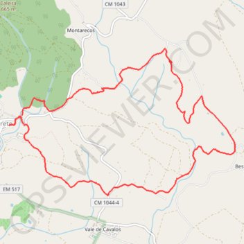
Name: Alegrete GPS track, route, trail
Start: CM 1044, Brejo, Alegrete, Portalegre, 7300-328, Portugal (39.24069 -7.31861)
End: Piscina Municipal de Alegrete, CM 1044, Alegrete, Portalegre, 7300-315, Portugal (39.24107 -7.31851)
Coordinates: 39.23041 -7.32070 39.24996 -7.28187
Other GPS tracks
Click on a GPS track to view route, its statistics and profile.
EuroVelo 1 (Spain)
Espagne > Andalousie > Côte occidentale > Ayamonte
Distance: 842.4 mi • Elevation gain: 14,587 m • Maximum elevation: 1,320 m
Eurovelo 01 Spain + Portugal
France > Nouvelle-Aquitaine > Pyrénées-Atlantiques > Hendaye
Distance: 1,930.7 mi • Elevation gain: 30,592 m • Maximum elevation: 1,503 m
Southern section — European Divide Trail
France > Auvergne-Rhône-Alpes > Drôme > Valence
Distance: 1,506.1 mi • Elevation gain: 42,375 m • Maximum elevation: 2,005 m
EuroVelo 1 (Spain)
Espagne > Andalousie > Côte occidentale > Ayamonte > Pozo del Camino > Fotea
Distance: 838.7 mi • Elevation gain: 13,641 m • Maximum elevation: 1,320 m
Stage 26: Valence to Saint-Jean-de-Fos — European Divide Trail
France > Auvergne-Rhône-Alpes > Drôme > Valence
Distance: 1,506.1 mi • Elevation gain: 42,375 m • Maximum elevation: 2,005 m
LLOR2022_Final_10K_CP
Portugal > Faro > Vila Real de Santo António > Monte Gordo
Distance: 587.8 mi • Elevation gain: 20,227 m • Maximum elevation: 1,130 m