Duinbossen_dehaan
- Distance: 6.9 mi
- Elevation gain: 62 m
- Maximum elevation: 12 m
- Elevation loss: 62 m
- Minimum elevation: 0 m
Interactive map
GPS track profile
About this GPS track
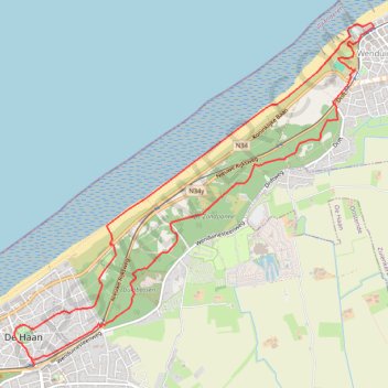
Name: Duinbossen_dehaan GPS track, route, trail
Coordinates: 51.27269 3.03051 51.30162 3.07904
Other GPS tracks
Click on a GPS track to view route, its statistics and profile.
TET_B-01-NW_20230301
Pays-Bas > Brabant-Septentrional > Reusel
Distance: 278.3 mi • Elevation gain: 3,174 m • Maximum elevation: 164 m
De Bruxelles vers la mer du Nord GR
Belgique > Brabant flamand > Hal-Vilvorde > Merchtem
Randonnée entre Merchtem et Oostende. #Randonnée
Distance: 149.1 mi • Elevation gain: 669 m • Maximum elevation: 71 m
Rando Paris-Amsterdam
France > Île-de-France > Paris
Vélo. En aller simple entre Paris et Amsterdam. #Vélo
Distance: 442.2 mi • Elevation gain: 4,337 m • Maximum elevation: 247 m
Itinéraire de Hoofdweg 182III, 1057 DD Amsterdam, Pays-Bas à 9 Rue Louguet, 62100 Calais, France
Pays-Bas > Hollande-Septentrionale > Amsterdam
Distance: 221.2 mi • Elevation gain: 879 m • Maximum elevation: 21 m
Littoral
Belgique > Flandre-Occidentale > Furnes > La Panne
Distance: 40.9 mi • Elevation gain: 426 m • Maximum elevation: 22 m
TET_B-01-NW_20230301
Pays-Bas > Brabant-Septentrional > Reusel
Distance: 278.3 mi • Elevation gain: 3,174 m • Maximum elevation: 164 m
T3_Blankenb-Oostend
Belgium > West Flanders > Brugge > Blankenberge
<p>Uit wandelgids 'Treinstapper 3'</p> <p><strong>GR 5A Kustroute</strong></p> <p>Een dagje 'uitwaaien aan zee'. Je wandelt een groot deel op de GR 5A en geniet van een voortdurende afwisseling: zee, strand, duinen, duinpaden en -bossen. Ontdek de 'aubette de la douane' of wat Einstein naar De Haan dreef. Op het einde wacht je de…
Distance: 14.6 mi • Elevation gain: 167 m • Maximum elevation: 16 m
Lus West-Vlaanderen, Noord
Belgique > Flandre-Occidentale > Bruges > Thourout > Sint-Pieter
Distance: 77.6 mi • Elevation gain: 230 m • Maximum elevation: 39 m