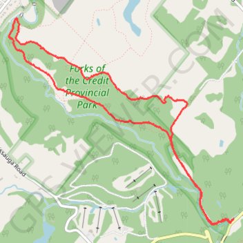
Bruce Trail Loop
Forks of the Credit Provincial Park. #Hike #Snowshoes #ForksOfTheCredit
- Distance: 4.8 mi
- Elevation gain: 172 m
- Maximum elevation: 404 m
- Elevation loss: 172 m
- Minimum elevation: 308 m
Interactive map
GPS track profile
About this GPS track
Name: Bruce Trail Loop GPS track, route, trail
Coordinates: 43.80263 -80.02262 43.82154 -79.99403
Other GPS tracks
Click on a GPS track to view route, its statistics and profile.
Orangeville - Brampton
Canada > Ontario > Dufferin County > Mono
Distance: 34.1 mi • Elevation gain: 206 m • Maximum elevation: 461 m