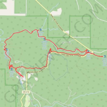
Silver Falls
Round trip. #Hike
- Distance: 8.6 mi
- Elevation gain: 613 m
- Maximum elevation: 503 m
- Elevation loss: 613 m
- Minimum elevation: 321 m
Interactive map
GPS track profile
About this GPS track
Name: Silver Falls GPS track, route, trail
Start: Silver Falls Drive Southeast, Marion County, Oregon, United States (44.87605 -122.65306)
End: Silver Falls Drive Southeast, Marion County, Oregon, United States (44.87611 -122.65302)
Coordinates: 44.87605 -122.66237 44.89219 -122.61513
Other GPS tracks
Click on a GPS track to view route, its statistics and profile.