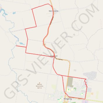
Memerambi
West side Memerambi and Crawford
- Distance: 23.6 mi
- Elevation gain: 294 m
- Maximum elevation: 558 m
- Elevation loss: 294 m
- Minimum elevation: 403 m
- Moving time: 1 h 56 m
- Moving speed: 12.1 mph
- Maximum speed: 28.3 mph
- Total time: 2 h 17 m
- Global speed: 10.3 mph
- Date: 03/04/24
Interactive map
GPS track profile
About this GPS track
Name: Memerambi GPS track, route, trail
Start: Wattle Street, Kingaroy, South Burnett Regional, Queensland, Australia (-26.52757 151.86066)
End: Wattle Street, Kingaroy, South Burnett Regional, Queensland, Australia (-26.52754 151.86064)
Coordinates: -26.54179 151.77976 -26.44357 151.86156
Other GPS tracks
Click on a GPS track to view route, its statistics and profile.
Booie and Schellbachs Road near Kingaroy
Australia > Queensland > Kingaroy
Distance: 14.4 mi • Elevation gain: 356 m • Maximum elevation: 591 m
Kingaroy to Goodger Queensland
Australia > Queensland > Kingaroy
Goodger, Taabinga, Kingaroy, Boonenne, Queensland
Distance: 23.8 mi • Elevation gain: 300 m • Maximum elevation: 542 m
Kingaroy Taabinga Boonenne trace
Australia > Queensland > Kingaroy
Loop bike around Kingaroy. #Bike #Loop #Countryside #Nature #Forest
Distance: 22.9 mi • Elevation gain: 368 m • Maximum elevation: 542 m
Murgon - Kingaroy
Australia > Queensland > Murgon
#Bike
Distance: 30.1 mi • Elevation gain: 335 m • Maximum elevation: 489 m