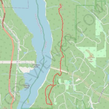
Rowntree road - Jocelyn Hill
Gowlland Tod Provincial Park. #Hike #GowllandTod
- Distance: 7.6 mi
- Elevation gain: 524 m
- Maximum elevation: 411 m
- Elevation loss: 524 m
- Minimum elevation: 179 m
Interactive map
GPS track profile
About this GPS track
Name: Rowntree road - Jocelyn Hill GPS track, route, trail
Coordinates: 48.50182 -123.53815 48.53720 -123.52839
Other GPS tracks
Click on a GPS track to view route, its statistics and profile.
Caleb Pike - Mount Finlayson - Holmes Peak
Canada > British Columbia > Capital Regional District > Highlands
Gowlland Tod Provincial Park. #Hike #Loop #GowllandTod
Distance: 7.1 mi • Elevation gain: 511 m • Maximum elevation: 406 m
Holmes Peak
Canada > British Columbia > Capital Regional District > Highlands
Gowlland Tod Provincial Park. #Hike #GowllandTod
Distance: 1.7 mi • Elevation gain: 123 m • Maximum elevation: 313 m