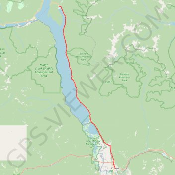
Crawford Bay - Creston
Kootenay Lake. #Bike
- Distance: 47.7 mi
- Elevation gain: 1,016 m
- Maximum elevation: 681 m
- Elevation loss: 969 m
- Minimum elevation: 539 m
Interactive map
GPS track profile
About this GPS track
Name: Crawford Bay - Creston GPS track, route, trail
Coordinates: 49.09597 -116.82092 49.67223 -116.51469
Other GPS tracks
Click on a GPS track to view route, its statistics and profile.
Départ - Alberta
Canada > Colombie-Britannique > District régional du Grand Vancouver > Vancouver
Distance: 1,613.6 mi • Elevation gain: 17,360 m • Maximum elevation: 2,042 m
Castlegar - Crawford Bay
Canada > British Columbia > Regional District of Central Kootenay > Area J (Lower Arrow/Columbia) > Raspberry
Kootenay River. #Bike
Distance: 56.6 mi • Elevation gain: 1,194 m • Maximum elevation: 694 m