Trail Planner Map
- Distance: 3.8 mi
- Elevation gain: 177 m
- Maximum elevation: 1,317 m
- Elevation loss: 177 m
- Minimum elevation: 1,170 m
Interactive map
GPS track profile
About this GPS track
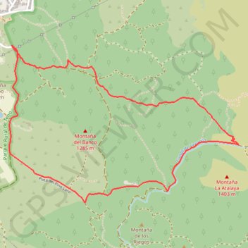
Name: Trail Planner Map GPS track, route, trail
Coordinates: 28.31100 -16.78774 28.32282 -16.76820
Other GPS tracks
Click on a GPS track to view route, its statistics and profile.
Trail Planner Map
Distance: 2.7 mi • Elevation gain: 126 m • Maximum elevation: 1,328 m