Ride 2022-01-02
- Distance: 25.1 mi
- Elevation gain: 1,155 m
- Maximum elevation: 361 m
- Elevation loss: 1,155 m
- Minimum elevation: 2 m
- Moving time: 2 h 48 m
- Moving speed: 9.0 mph
- Maximum speed: 30.8 mph
- Total time: 3 h 44 m
- Global speed: 6.7 mph
- Date: 02/01/22
Interactive map
GPS track profile
About this GPS track
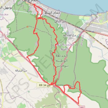
Name: Ride 2022-01-02 GPS track, route, trail
Start: Hammem Lif Ville 2, Délégation Hammam Lif, Gouvernorat Ben Arous, 2093, Tunisie (36.72691 10.34129)
End: Hammem Lif Ville 2, Délégation Hammam Lif, Gouvernorat Ben Arous, 2093, Tunisie (36.72682 10.34141)
Coordinates: 36.62772 10.33270 36.72710 10.40031
Other GPS tracks
Click on a GPS track to view route, its statistics and profile.
22 Oct 2023
Tunisie > Gouvernorat Tunis > Tunis
Distance: 40.8 mi • Elevation gain: 192 m • Maximum elevation: 86 m