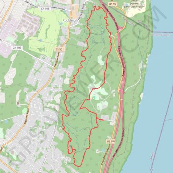
Alpine & Rockleigh
Palisades Interstate Park.
- Distance: 9.3 mi
- Elevation gain: 309 m
- Maximum elevation: 171 m
- Elevation loss: 309 m
- Minimum elevation: 41 m
- Moving time: 2 h 13 m
- Moving speed: 4.2 mph
- Maximum speed: 23.5 mph
- Total time: 2 h 20 m
- Global speed: 4.0 mph
- Date: 09/04/24
Interactive map
GPS track profile
About this GPS track
Name: Alpine & Rockleigh GPS track, route, trail
Start: 17, Ruckman Road, Alpine, Bergen County, New Jersey, 07620, United States (40.97503 -73.91955)
End: 18, Ruckman Road, Alpine, Bergen County, New Jersey, 07620, United States (40.97495 -73.91957)
Coordinates: 40.96317 -73.93324 41.00386 -73.91651
Other GPS tracks
Click on a GPS track to view route, its statistics and profile.
Rockleigh Woods Sanctuary
United States > New Jersey > Bergen County > Rockleigh
Distance: 6.8 mi • Elevation gain: 325 m • Maximum elevation: 150 m
Palisades Interstate Park Mountain Bike Ride
United States > New Jersey > Bergen County > Rockleigh
Distance: 8.5 mi • Elevation gain: 330 m • Maximum elevation: 162 m
Montréal - New York
Canada > Québec > Agglomération de Montréal > Montréal
Distance: 396.0 mi • Elevation gain: 4,134 m • Maximum elevation: 301 m