The Old Man of Storr
GPX file from Walkhighlands; file is copyright Walkhighlands and must not be publicly shared on other websites. Do not remove this notice.
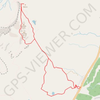
- Distance: 3.2 mi
- Elevation gain: 335 m
- Maximum elevation: 493 m
- Elevation loss: 335 m
- Minimum elevation: 169 m
Interactive map
GPS track profile
About this GPS track
Name: The Old Man of Storr GPS track, route, trail
Start: A855, Highland, Écosse, IV51 9HX, Royaume-Uni (57.49830 -6.15838)
End: A855, Highland, Écosse, IV51 9HX, Royaume-Uni (57.49846 -6.15815)
Coordinates: 57.49699 -6.17600 57.51140 -6.15815
Other GPS tracks
Click on a GPS track to view route, its statistics and profile.
Skye Trail
Royaume-Uni > Écosse > Highland > Shulista
Distance: 79.2 mi • Elevation gain: 3,959 m • Maximum elevation: 655 m
The Storr - ascent
Royaume-Uni > Écosse > Highland
GPX file from Walkhighlands; file is copyright Walkhighlands and must not be publicly shared on other websites. Do not remove this notice.
Distance: 4.9 mi • Elevation gain: 569 m • Maximum elevation: 708 m