Import a GPX file

Four Rivers and Five Trails Loop

Loop hike along Monongahela River. #Hike #Loop #River #Nature #City

  • Distance: 38.9 mi
  • Elevation gain: 687 m
  • Maximum elevation: 339 m
  • Elevation loss: 686 m
  • Minimum elevation: 212 m
  • Moving time: 10 h 1 m
  • Moving speed: 3.9 mph
  • Maximum speed: 14.9 mph
  • Total time: 10 h 38 m
  • Global speed: 3.7 mph
  • Date: 01/05/21

Interactive map

GPS track profile

About this GPS track
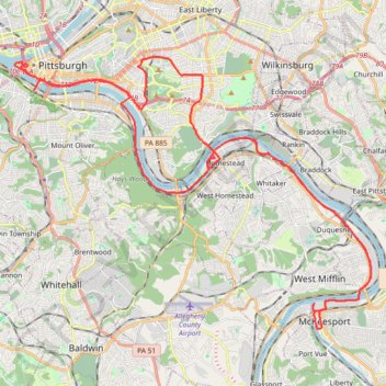
Other GPS tracks

Click on a GPS track to view route, its statistics and profile.

Point State to Emerald View Loop

United States > Pennsylvania > Allegheny County > Pittsburgh

Loop hike from Point State Park through Emerald View Park via Monongahela River, Smithfield Street Bridge, Grandview Avenue and Emerald View Trail. #Hike #Loop #Nature #Park #River #Forest #City

Distance: 12.3 mi • Elevation gain: 761 m • Maximum elevation: 352 m

Schenley Park and Monongahela River Loop

United States > Pennsylvania > Allegheny County > Pittsburgh

Loop hike through Schenley Park and along Monongahela River. #Hike #Loop #Nature #City #Park #Forest #River

Distance: 17.5 mi • Elevation gain: 395 m • Maximum elevation: 340 m