Import a GPX file

Mount Washington, Lion Head and Tuckerman Ravine Loop

Loop hike from Pinkham Notch to Mount Washington via Tuckerman Ravine Trail, Crystal Cascades Falls and Lion Head Trail in the Pinkham Notch Scenic Area, the Mount Washington State Park and the White Mountain National Forest. #Hike #Loop #Mountain #Nature #Forest #Falls #Park

  • Distance: 7.8 mi
  • Elevation gain: 1,325 m
  • Maximum elevation: 1,911 m
  • Elevation loss: 1,324 m
  • Minimum elevation: 617 m
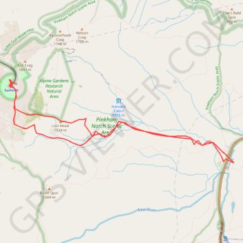
Interactive map

GPS track profile

About this GPS track

Name: Mount Washington, Lion Head and Tuckerman Ravine Loop GPS track, route, trail

Start: Tuckerman Ravine Trail, Pinkham's Grant, Coös County, New Hampshire, United States (44.26036 -71.25531)

End: Tuckerman Ravine Trail, Pinkham's Grant, Coös County, New Hampshire, United States (44.26042 -71.25528)

Coordinates: 44.25703 -71.30351 44.27103 -71.25048

Other GPS tracks

Click on a GPS track to view route, its statistics and profile.

Québec - Montréal - Saint-Laurent River - Lake Ontario - Niagara Falls

Canada > Quebec > Urban agglomeration of Québec > Quebec

#Bike #Ontario

Distance: 670.1 mi • Elevation gain: 4,804 m • Maximum elevation: 209 m

Presidential Range Traverse

United States > New Hampshire > Coos County > Bowman

Hike via Mount Madison, Mount Adams, Mount Jefferson, Mount Washington, Mount Monroe, Mount Franklin, Mount Eisenhower, Mount Pierce and Mount Jackson in the White Mountain National Forest. #Hike #Mountain #Forest #Nature #Lake

Distance: 20.1 mi • Elevation gain: 2,545 m • Maximum elevation: 1,911 m