3:38
- Distance: 26.6 mi
- Elevation gain: 212 m
- Maximum elevation: 57 m
- Elevation loss: 212 m
- Minimum elevation: 33 m
- Moving time: 3 h 48 m
- Moving speed: 7.0 mph
- Maximum speed: 13.0 mph
- Total time: 3 h 57 m
- Global speed: 6.7 mph
- Date: 25/09/22
Interactive map
GPS track profile
About this GPS track
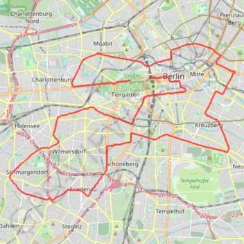
Name: 3:38 GPS track, route, trail
Start: Straße des 17. Juni, Tiergarten, Mitte, Berlin, 10785, Allemagne (52.51516 13.36061)
End: Straße des 17. Juni, Tiergarten, Mitte, Berlin, 10557, Allemagne (52.51600 13.37250)
Coordinates: 52.46753 13.28123 52.52984 13.42899
Other GPS tracks
Click on a GPS track to view route, its statistics and profile.
NC4K_22_03
Allemagne > Saxe > Vogtlandkreis > Muldenberg
Distance: 196.5 mi • Elevation gain: 1,975 m • Maximum elevation: 725 m