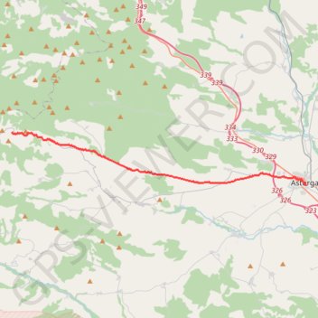
SE33-Astorga-Foncebadón
Total: 26.4km
- Distance: 16.3 mi
- Elevation gain: 616 m
- Maximum elevation: 1,438 m
- Elevation loss: 42 m
- Minimum elevation: 858 m
Interactive map
GPS track profile
About this GPS track
Name: SE33-Astorga-Foncebadón GPS track, route, trail
Start: Calle Puerta del Sol, Astorga, León, Castille-et-León, 24700, Espagne (42.45302 -6.05133)
Coordinates: 42.45302 -6.34343 42.49210 -6.05133
Other GPS tracks
Click on a GPS track to view route, its statistics and profile.
Southern section — European Divide Trail
France > Auvergne-Rhône-Alpes > Drôme > Valence
Distance: 1,506.1 mi • Elevation gain: 42,375 m • Maximum elevation: 2,005 m
Camino Francés (Chemin des Français)
France > Nouvelle-Aquitaine > Pyrénées-Atlantiques > Saint-Jean-Pied-de-Port > Larroinea
Pèlerinage de Saint-Jacques-de-Compostelle depuis Saint-Jean-Pied-de-Port. #Randonnée #Compostelle #Espagne #Pyrénées #Nature #Campagne #Montagne #Cantabrica #Cantabrique
Distance: 466.6 mi • Elevation gain: 11,690 m • Maximum elevation: 1,510 m
Chemin de Saint-Jacques-de-Compostelle de Saint-Germain-des-Prés à Cap Finisterre
France > Centre-Val de Loire > Loiret > Saint-Germain-des-Prés > Montantaume
Randonnée. En aller simple entre Saint-Germain-des-Prés et Fisterra. #Randonnée #Compostelle
Distance: 1,358.7 mi • Elevation gain: 43,041 m • Maximum elevation: 1,608 m
EuroVelo 1 (Spain)
Espagne > Andalousie > Côte occidentale > Ayamonte
Distance: 842.4 mi • Elevation gain: 14,587 m • Maximum elevation: 1,320 m
Eurovelo 01 Spain + Portugal
France > Nouvelle-Aquitaine > Pyrénées-Atlantiques > Hendaye
Distance: 1,930.7 mi • Elevation gain: 30,592 m • Maximum elevation: 1,503 m
Compostelle a Velo - ESPAGNE
Espagne > Pirinioak / Pirineo > Roncevaux
Distance: 611.1 mi • Elevation gain: 13,858 m • Maximum elevation: 1,505 m
CAMINO FRANCES 1ª PARTE 001
France > Nouvelle-Aquitaine > Pyrénées-Atlantiques > Saint-Jean-Pied-de-Port > Larroinea
Distance: 468.2 mi • Elevation gain: 11,710 m • Maximum elevation: 1,509 m
Camino Frances Main Track
France > Nouvelle-Aquitaine > Pyrénées-Atlantiques > Saint-Jean-Pied-de-Port > Larroinea
Distance: 534.0 mi • Elevation gain: 15,262 m • Maximum elevation: 1,506 m
Stage 26: Valence to Saint-Jean-de-Fos — European Divide Trail
France > Auvergne-Rhône-Alpes > Drôme > Valence
Distance: 1,506.1 mi • Elevation gain: 42,375 m • Maximum elevation: 2,005 m
EuroVelo 1 (Spain)
Espagne > Andalousie > Côte occidentale > Ayamonte > Pozo del Camino > Fotea
Distance: 838.7 mi • Elevation gain: 13,641 m • Maximum elevation: 1,320 m
SE34-Foncebadón-Ponferrada
Espagne > Castille-et-León > Santa Colomba de Somoza > Foncebadón
Total: 27.5km
Distance: 17.0 mi • Elevation gain: 282 m • Maximum elevation: 1,510 m
(tous)_saint_Jacques_de_Compostelle_1600Km
France > Auvergne-Rhône-Alpes > Haute-Loire > Le Puy-en-Velay
Distance: 1,000.5 mi • Elevation gain: 29,751 m • Maximum elevation: 1,502 m
De Villeneuve-sur-Lot à Guimarães
France > Nouvelle-Aquitaine > Lot-et-Garonne > Villeneuve-sur-Lot
Distance: 1,257.8 mi • Elevation gain: 22,121 m • Maximum elevation: 1,339 m
18/10/2020 12:05:36
Espagne > Pays basque autonome > Basse-Bidassoa > Fontarrabie
18/10/2020 12:05:36
Distance: 1,097.2 mi • Elevation gain: 32,710 m • Maximum elevation: 1,607 m
Saint Jean Pied de Port - Fiesterra
France > Nouvelle-Aquitaine > Pyrénées-Atlantiques > Saint-Jean-Pied-de-Port > Larroinea
Distance: 473.0 mi • Elevation gain: 12,203 m • Maximum elevation: 1,502 m
Trace
France > Nouvelle-Aquitaine > Pyrénées-Atlantiques > Saint-Jean-Pied-de-Port > Larroinea
Distance: 472.3 mi • Elevation gain: 12,409 m • Maximum elevation: 1,510 m
SE32-LaBaneza-Astorga
Espagne > Castille-et-León > La Bañeza
Total: 24.8km
Distance: 15.4 mi • Elevation gain: 186 m • Maximum elevation: 872 m