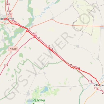
SE29-Villalpando-Benavente
Total: 30.4km
- Distance: 18.8 mi
- Elevation gain: 180 m
- Maximum elevation: 751 m
- Elevation loss: 158 m
- Minimum elevation: 684 m
Interactive map
GPS track profile
About this GPS track
Name: SE29-Villalpando-Benavente GPS track, route, trail
Start: Plaza Angustias, Villalpando, Zamora, Castille-et-León, Espagne (41.86421 -5.41352)
Coordinates: 41.86421 -5.68265 42.00320 -5.41352
Other GPS tracks
Click on a GPS track to view route, its statistics and profile.
Southern section — European Divide Trail
France > Auvergne-Rhône-Alpes > Drôme > Valence
Distance: 1,506.1 mi • Elevation gain: 42,375 m • Maximum elevation: 2,005 m
EuroVelo 1 (Spain)
Espagne > Andalousie > Côte occidentale > Ayamonte
Distance: 842.4 mi • Elevation gain: 14,587 m • Maximum elevation: 1,320 m
Eurovelo 01 Spain + Portugal
France > Nouvelle-Aquitaine > Pyrénées-Atlantiques > Hendaye
Distance: 1,930.7 mi • Elevation gain: 30,592 m • Maximum elevation: 1,503 m
Stage 26: Valence to Saint-Jean-de-Fos — European Divide Trail
France > Auvergne-Rhône-Alpes > Drôme > Valence
Distance: 1,506.1 mi • Elevation gain: 42,375 m • Maximum elevation: 2,005 m
EuroVelo 1 (Spain)
Espagne > Andalousie > Côte occidentale > Ayamonte > Pozo del Camino > Fotea
Distance: 838.7 mi • Elevation gain: 13,641 m • Maximum elevation: 1,320 m
De Villeneuve-sur-Lot à Guimarães
France > Nouvelle-Aquitaine > Lot-et-Garonne > Villeneuve-sur-Lot
Distance: 1,257.8 mi • Elevation gain: 22,121 m • Maximum elevation: 1,339 m
18/10/2020 12:05:36
Espagne > Pays basque autonome > Basse-Bidassoa > Fontarrabie
18/10/2020 12:05:36
Distance: 1,097.2 mi • Elevation gain: 32,710 m • Maximum elevation: 1,607 m