Randonnée du 12/05/2022 à 07:29
- Distance: 4.3 mi
- Elevation gain: 266 m
- Maximum elevation: 119 m
- Elevation loss: 312 m
- Minimum elevation: 3 m
- Moving time: 2 h 24 m
- Moving speed: 1.8 mph
- Maximum speed: 18.0 mph
- Total time: 3 h 35 s
- Global speed: 1.4 mph
- Date: 12/05/22
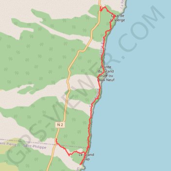
Interactive map
GPS track profile
About this GPS track
Name: Randonnée du 12/05/2022 à 07:29 GPS track, route, trail
Start: N 2, Sainte-Rose, Saint-Benoît, La Réunion, 97439, France (-21.24981 55.79661)
End: N 2, Sainte-Rose, Saint-Benoît, La Réunion, 97439, France (-21.22049 55.80710)
Coordinates: -21.25551 55.79661 -21.22049 55.81054
Other GPS tracks
Click on a GPS track to view route, its statistics and profile.
🚶 Trace ,boucle du tour de La Réunion par La Montagne
France > La Réunion > Saint-Denis
🌍 Tag : #FranceTourisme #OfficeTourisme #RandonnéesFrance 🚶 Par - Bons plans en France ,Outre-mers : https://www.google.com/maps/d/embed?mid=1VJ6s4u13Cn0OaTEAOgdmNOh9tNxCCnno
Distance: 186.6 mi • Elevation gain: 6,413 m • Maximum elevation: 1,209 m