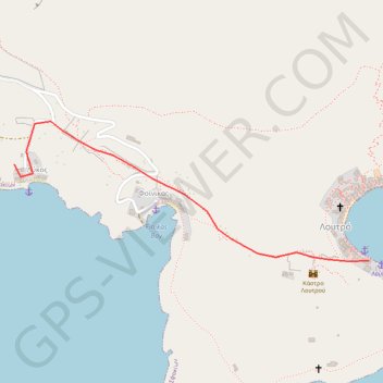
Crete J13 Lycos Loutro
Randonnée pédestre. En aller simple. #Randonnée
- Distance: 0.9 mi
- Elevation gain: 91 m
- Maximum elevation: 64 m
- Elevation loss: 103 m
- Minimum elevation: 5 m
- Moving time: 34 m 31 s
- Moving speed: 1.6 mph
- Maximum speed: 2.3 mph
- Total time: 54 m 27 s
- Global speed: 1.0 mph
- Date: 06/10/13
Interactive map
GPS track profile
About this GPS track
Name: Crete J13 Lycos Loutro GPS track, route, trail
Coordinates: 35.19815 24.06677 35.20225 24.07948
Other GPS tracks
Click on a GPS track to view route, its statistics and profile.
Loutro - Agia Roumeli
Grèce > Région Crète > Περιφερειακή Ενότητα Χανίων > Loutró > Φοίνικας
Randonnée pédestre. En aller simple. #Randonnée
Distance: 9.5 mi • Elevation gain: 548 m • Maximum elevation: 116 m
Loutro - Sweet Water
Grèce > Région Crète > Περιφερειακή Ενότητα Χανίων > Loutró > Φοίνικας
Randonnée en aller-retour depuis Loutro. #Randonnée
Distance: 3.9 mi • Elevation gain: 295 m • Maximum elevation: 60 m